Strong wind, blowing dust and sprinkles 10 December 2021
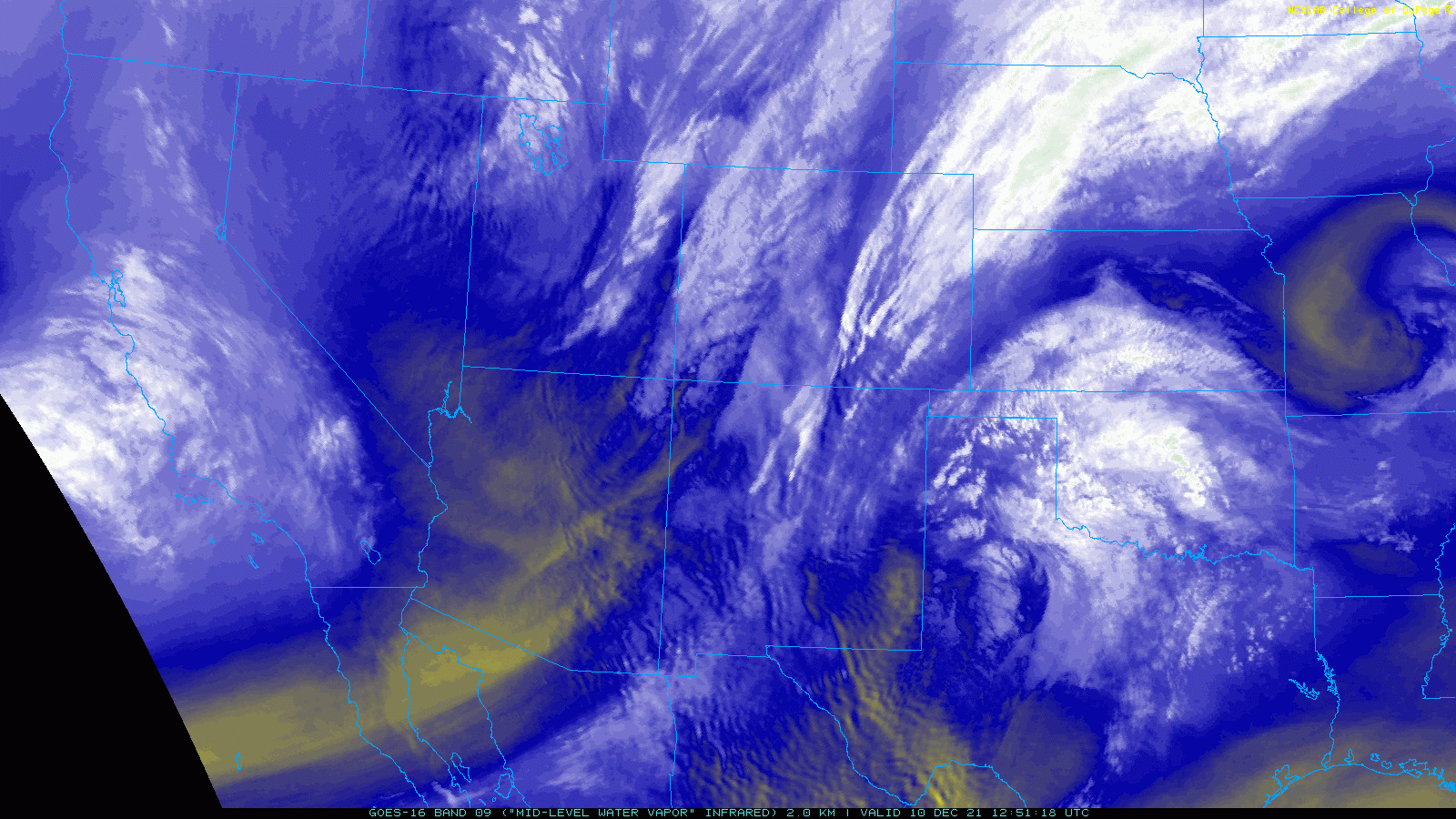
Water vapor loop from 6:51 am to 7:31 am on Friday (10 December 2021).
A powerful storm system ejecting from the southern Rockies, which ingested a couple of smaller disturbance, brought major impacts to the center of the nation, including here in West Texas on Friday (10 December). Where the system encountered better moisture, severe thunderstorms erupted across the central Mississippi River Valley, producing numerous tornadoes that caused major damage and killed tens of people. On the cold side of the system, a swath of heavy snow fell from the central and southern Rockies into parts of the Upper Midwest.
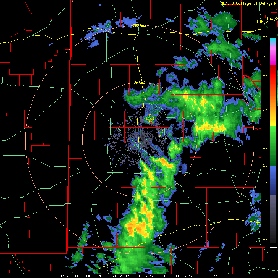
Lubbock WSR-88D base reflectivity loop valid from 6:19 am to 9:05 am 10 December 2021.
Here in West Texas, we ended up on the dry and windy southern side of the system, as often happens with these potent winter storms. Enough mid-level moisture and lift did race across the region early in the day to provide a few sprinkles and light showers from the eastern South Plains through the Rolling Plains and southeast Texas Panhandle, though rainfall was spotty and light, generally trace amounts.
West Texas Mesonet LiDAR wind data (m/s) sampled at Reese Center on 10 December 2021.
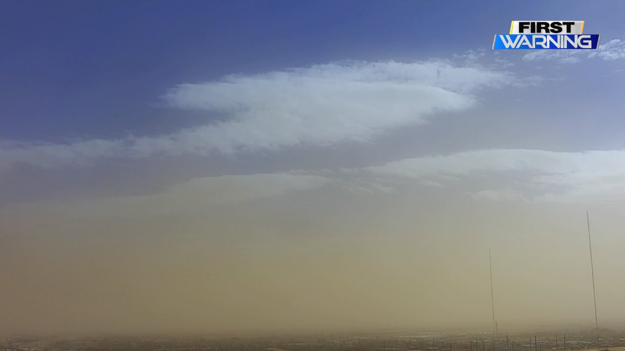
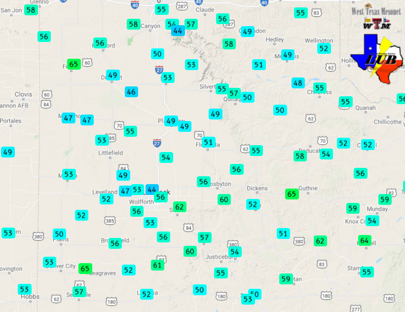
When the clouds cleared and temperatures warmed, we quickly tapped the intense westerly winds moving across the region not far above ground level. Wind speeds quickly jumped, peaking in the 30 to 40 mph range, sometimes higher, while wind gusts reached 50 to 60+ mph from late morning through mid-late afternoon. The strongest winds in the late morning and early afternoon were concentrated in a band from the southern South Plains through the southern and central Rolling Plains, where several locations recorded gusts as high as 60 to 65 mph. Impressively, the Lubbock Airport reported a peak wind gust of 67 mph during this period as well. The intense winds lofted several bands of dust, dropping the visibility to 2 miles or lower at times, and likely much lower downwind of open fields.
Dusty Lubbock skyline captured around midday on 10 December 2021. The picture is courtesy of Jack Maney and KLBK.
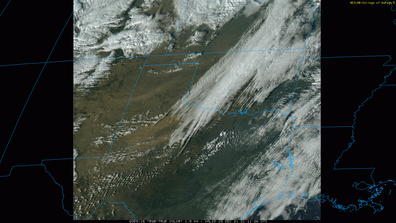
Another bout of lift and mid-level moisture generated clouds and spotty sprinkles across the South Plains during the mid-afternoon. Although only trace amounts of rain accompanied this activity, the showers did locally enhance the wind and blowing dust. One such "dirt" shower generated a second 67 mph wind gust at the Lubbock Airport just before 3 pm.
"True Color" satellite loop valid from 3:11 pm to 3:22 pm on 10 December 2021.
The windy and dusty day was accompanied by mild/warm temperatures that peaked in the 60s and 70s at most locations. In addition, as the relative humidity dropped to around and even under 20%, conditions grew favorable for wildfire development and spread as fuels (mostly grasses) have gone dormant and significantly dried through the fall. Numerous wildfires developed through the mid-late afternoon across the region, most concentrated from western North Texas into southwestern Oklahoma. A few fires developed even further west across the Texas Panhandle and Rolling Plains, including one fire that ignited between Roaring Springs and Matador.
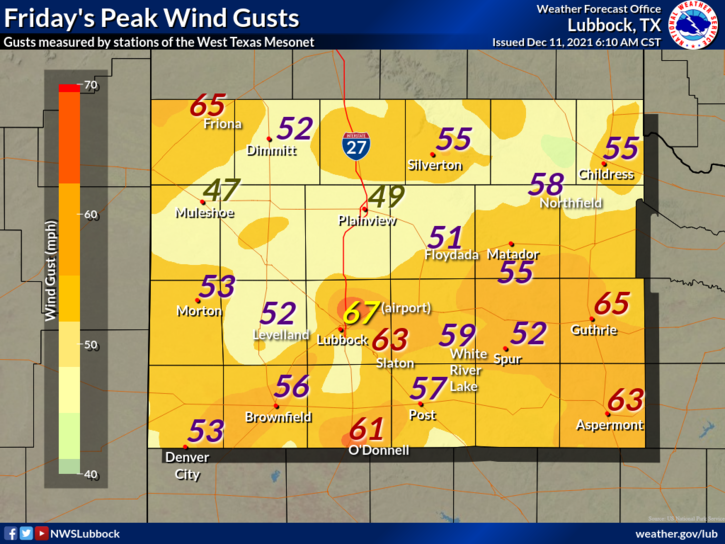
Peak wind gusts recorded by the West Texas Mesonet (WTM) on Friday, 10 December 2021. The peak wind speeds measured by the WTM on the 10th can be VIEWED HERE. A contoured plot of the peak wind gust on the 10th can be seen HERE.
Thankfully, conditions gradually improved as winds decreased during the evening. A strong cold front followed, carrying much cooler air into the region on gusty northerly winds late Friday night, as the storm system pulled away from the region. Temperatures abruptly dropped from the 50s and 60s in advance of the front to the 30s and 40s behind the front. Lows by Saturday morning (11 December) ended up in the 20s and 30s, with a few teens over the southwest Texas Panhandle.
The preliminary storm reports collected over this windy December day can be found below.
Wind Reports from NWS Lubbock on December 10th
PRELIMINARY LOCAL STORM REPORT...SUMMARY
NATIONAL WEATHER SERVICE LUBBOCK TX
817 PM CST FRI DEC 10 2021

..TIME...   ...EVENT...      ...CITY LOCATION...     ...LAT.LON...
..DATE...   ....MAG....      ..COUNTY LOCATION..ST.. ...SOURCE....
            ..REMARKS..

1035 AM     NON-TSTM WND GST 6 NNE LUBBOCK           33.67N 101.82W
12/10/2021  M59 MPH          LUBBOCK            TX   ASOS

1058 AM     NON-TSTM WND GST 10 SW PADUCAH           33.89N 100.40W
12/10/2021  M58 MPH          COTTLE             TX   MESONET

            WEST TEXAS MESONET OBSERVATION.

1110 AM     NON-TSTM WND GST 6 NNE LUBBOCK           33.67N 101.82W
12/10/2021  M67 MPH          LUBBOCK            TX   ASOS

1115 AM     NON-TSTM WND GST 2 NE SLATON             33.46N 101.62W
12/10/2021  M62 MPH          LUBBOCK            TX   MESONET

            WEST TEXAS MESONET OBSERVATION. ADDITIONAL GUSTS TO 61
            MPH OCCURRED AT 1139 AM AND 1140 AM.

1133 AM     NON-TSTM WND GST 3 NE ASPERMONT          33.17N 100.20W
12/10/2021  M58 MPH          STONEWALL          TX   MESONET

            WEST TEXAS MESONET OBSERVATION.

1206 PM     NON-TSTM WND GST 10 WSW GUTHRIE          33.57N 100.48W
12/10/2021  M60 MPH          KING               TX   MESONET

            WEST TEXAS MESONET OBSERVATION.

1209 PM     NON-TSTM WND GST 10 WSW GUTHRIE          33.57N 100.48W
12/10/2021  M65 MPH          KING               TX   MESONET

            WEST TEXAS MESONET OBSERVATION. A 65 MPH GUST WAS ALSO
            MEASURED AT 1216 PM. SEVERAL GUSTS OF 58 TO 65 MPH
            OCCURRED BETWEEN 1217 PM AND 132 PM.

1212 PM     NON-TSTM WND GST 3 NE ASPERMONT          33.17N 100.20W
12/10/2021  M62 MPH          STONEWALL          TX   MESONET

            WEST TEXAS MESONET OBSERVATION. ADDITIONAL GUSTS OF 59
            TO 60 MPH OCCURRED BETWEEN 1152 AM AND 1215 PM.

0106 PM     NON-TSTM WND GST 5 SSW GRAHAM            33.08N 101.52W
12/10/2021  M59 MPH          GARZA              TX   MESONET

            WEST TEXAS MESONET OBSERVATION.

0146 PM     NON-TSTM WND GST 1 W O`DONNELL           32.97N 101.85W
12/10/2021  M61 MPH          LYNN               TX   MESONET

            WEST TEXAS MESONET OBSERVATION. ADDITIONAL GUSTS OF 58
            TO 60 MPH OCCURRED FROM 0148 PM TO 0205 PM.

0204 PM     NON-TSTM WND GST 5 SSW GRAHAM            33.08N 101.52W
12/10/2021  M60 MPH          GARZA              TX   MESONET

            WEST TEXAS MESONET OBSERVATION. ADDITIONAL GUSTS OF 58
            TO 60 MPH OCCURRED BETWEEN 202 PM AND 224 PM.

0251 PM     NON-TSTM WND GST 6 NNE LUBBOCK           33.67N 101.82W
12/10/2021  M67 MPH          LUBBOCK            TX   ASOS

            ADDITIONAL GUSTS BETWEEN 58 MPH AND 64 MPH ALSO
            OCCURRED BETWEEN AND 1111 AM AND 142 PM.

0331 PM     NON-TSTM WND GST 2 NE FRIONA             34.65N 102.69W
12/10/2021  M65 MPH          PARMER             TX   MESONET

            WEST TEXAS MESONET OBSERVATION. ADDITIONAL GUSTS OF 58
            TO 62 MPH OCCURRED BETWEEN 332 PM AND 333 PM.
Wind Reports from NWS Amarillo from December 10th
PRELIMINARY LOCAL STORM REPORT...SUMMARY
NATIONAL WEATHER SERVICE AMARILLO TX
914 PM CST FRI DEC 10 2021

..TIME...   ...EVENT...      ...CITY LOCATION...     ...LAT.LON...
..DATE...   ....MAG....      ..COUNTY LOCATION..ST.. ...SOURCE....
            ..REMARKS..

0158 PM     NON-TSTM WND GST 6 WSW ADRIAN            35.25N 102.76W
12/10/2021  M58 MPH          OLDHAM             TX   MESONET

            MESONET STATION 109 ADRIAN 6WSW.

0305 PM     NON-TSTM WND GST 6 E CANADIAN            35.92N 100.28W
12/10/2021  M58 MPH          HEMPHILL           TX   MESONET

            MESONET STATION 67 CANADIAN 6E.

0314 PM     NON-TSTM WND GST 2 WNW LAKE MCCLELLAN    35.23N 100.90W
12/10/2021  M58 MPH          GRAY               TX   MESONET

            MESONET STATION 121 LAKE MCCLELLAN 2NW.
            INITIAL 58 MPH GUST OCCURRED AT 1240 PM.

0135 PM     NON-TSTM WND GST 2 N SPEARMAN            36.22N 101.19W
12/10/2021  M58 MPH          HANSFORD           TX   MESONET

            MESONET STATION KE42 MAJOR SAMUEL B
            CORNELIUS FIELD A.

1147 AM     NON-TSTM WND GST 15 WSW CLARENDON        34.82N 101.12W
12/10/2021  M58 MPH          ARMSTRONG          TX   MESONET

            MESONET STATION 108 PALO DURO 4E (JA RANCH).

1215 PM     NON-TSTM WND GST 1 SSW PANHANDLE         35.33N 101.39W
12/10/2021  M58 MPH          CARSON             TX   MESONET

            MESONET STATION 94 PANHANDLE 1SSW.

1154 AM     NON-TSTM WND GST 3 NNE UMBARGER          34.99N 102.08W
12/10/2021  M58 MPH          RANDALL            TX   MESONET

            MESONET STATION 76 UMBARGER 3NNE.

1243 PM     NON-TSTM WND GST 15 WSW CLARENDON        34.82N 101.12W
12/10/2021  M58 MPH          ARMSTRONG          TX   MESONET

            MESONET STATION 108 PALO DURO 4E (JA RANCH).

0215 PM     NON-TSTM WND GST 7 ENE STINNETT          35.85N 101.32W
12/10/2021  M58 MPH          HUTCHINSON         TX   MESONET

            MESONET STATION DT101 7.1 E STINNETT (DTN).

1146 AM     NON-TSTM WND GST 10 ESE VALLEY DE ORO    35.42N 101.93W
12/10/2021  M59 MPH          POTTER             TX   MESONET

            MESONET STATION 82 AMARILLO 15NNW.

0235 PM     NON-TSTM WND GST 2 WSW SANFORD           35.69N 101.57W
12/10/2021  M59 MPH          HUTCHINSON         TX   MESONET

            MESONET STATION CEDT2 CEDAR (RAWS).

0115 PM     NON-TSTM WND GST 3 WSW DUMAS             35.85N 102.02W
12/10/2021  M59 MPH          MOORE              TX   AWOS

            AWOS STATION KDUX DUMAS (AWOS).

1131 AM     NON-TSTM WND GST 6 ESE LORA              35.71N 100.46W
12/10/2021  M59 MPH          HEMPHILL           TX   MESONET

            MIAMI WT MESONET. MEASURED GUSTS OF 58 MPH
            OR GREATER FROM 1111 AM TO 1131 AM.

1201 PM     NON-TSTM WND GST 3 SE PANTEX             35.30N 101.54W
12/10/2021  M60 MPH          CARSON             TX   MESONET

            PANTEX WT MESONET.

1057 AM     NON-TSTM WND GST 4 SSW DALHART           36.02N 102.55W
12/10/2021  M60 MPH          HARTLEY            TX   ASOS

            CORRECTS PREVIOUS NON-TSTM WND GST REPORT
            FROM 4 SSW DALHART. ASOS STATION KDHT
            DALHART (ASOS). GUSTS TO 58 MPH OR MORE
            BEGAN AT 1044 AM AND CONTINUED THROUGH 254
            PM.

0131 PM     NON-TSTM WND GST 12 S CONLEN             36.06N 102.24W
12/10/2021  M61 MPH          DALLAM             TX   MESONET

            MESONET STATION FW2126 DALHART.

1038 AM     NON-TSTM WND GST 9 NW WAKA               36.36N 101.18W
12/10/2021  M61 MPH          HANSFORD           TX   MESONET

            CORRECTS PREVIOUS NON-TSTM WND GST REPORT
            FROM 9 NW WAKA. MESONET STATION 119 PALO
            DURO RESERVOIR 1NW. GUSTS TO 58 MPH OR MORE
            BEGAN AT 1011 AM AND CONTINUED THROUGH 1153
            AM.

1227 PM     NON-TSTM WND GST 2 ESE PAMPA             35.54N 100.93W
12/10/2021  M62 MPH          GRAY               TX   MESONET

            MESONET STATION 40 PAMPA 2E.

0133 PM     NON-TSTM WND GST 7 ENE STINNETT          35.85N 101.32W
12/10/2021  M62 MPH          HUTCHINSON         TX   MESONET

            MESONET STATION DT101 7.1 E STINNETT (DTN).
            GUSTS TO 58 MPH OR MORE FROM 1138 AM TO 244
            PM.

0133 PM     NON-TSTM WND GST 2 N STINNETT            35.84N 101.45W
12/10/2021  M62 MPH          HUTCHINSON         TX   MESONET

            MESONET STATION 104 STINNETT 1NNW. GUSTS TO
            58 MPH OR MORE BEGAN AT 1138 AM AND
            CONTINUED THROUGH 155 PM.

0153 PM     NON-TSTM WND GST 2 N STINNETT            35.84N 101.45W
12/10/2021  M62 MPH          HUTCHINSON         TX   MESONET

            MESONET STATION 104 STINNETT 1NNW.

1126 AM     NON-TSTM WND GST 9 NNE SUNRAY            36.14N 101.78W
12/10/2021  M62 MPH          SHERMAN            TX   MESONET

            CORRECTS PREVIOUS NON-TSTM WND GST REPORT
            FROM 9 NNE SUNRAY. SUNRAY 9 NNE MESONET.
            GUSTS OF 58 MPH OR GREATER PERIODICALLY FROM
            1126 AM TO 205 PM.

0221 PM     NON-TSTM WND GST 4 WNW STRATFORD         36.36N 102.14W
12/10/2021  M65 MPH          SHERMAN            TX   MESONET

            MAX SUSTAINED WIND OF 40 MPH STARTED AT 9:34
            AM AND ENDED AT 2:25 PM.

0208 PM     NON-TSTM WND GST 4 E VEGA                35.24N 102.35W
12/10/2021  M66 MPH          OLDHAM             TX   PUBLIC

            VEGA 4E WT MESONET MEASURED GUSTS AT OR
            ABOVE 58 MPH PERIODICALLY FROM 1043 AM TO
            243 PM.

0218 PM     NON-TSTM WND GST 7 E BORGER              35.67N 101.28W
12/10/2021  M67 MPH          HUTCHINSON         TX   MESONET

            CORRECTS PREVIOUS NON-TSTM WND GST REPORT
            FROM 7 E BORGER. BORGER WT MESONET. GUSTS OF
            58 OR GREATER PERIODICALLY FROM 1127 AM TO
            252 PM.

1156 AM     NON-TSTM WND GST 1 WSW GUYMON            36.68N 101.50W
12/10/2021  M69 MPH          TEXAS              OK   ASOS

            ASOS STATION KGUY GUYMON (ASOS). GUSTS TO 58
            MPH OR MORE BEGAN AT 913 AM AND CONTINUED
            THROUGH 1250 PM.

0313 PM     NON-TSTM WND GST 6 E AMARILLO            35.22N 101.72W
12/10/2021  M70 MPH          POTTER             TX   ASOS

            ASOS STATION KAMA AMARILLO (ASOS). GUSTS TO
            58 MPH OR MORE BEGAN AT 945 AM AND CONTINUED
            THROUGH 340 PM.

0233 PM     NON-TSTM WND GST 2 WNW FRITCH            35.65N 101.62W
12/10/2021  M71 MPH          MOORE              TX   MESONET

            MESONET STATION 114 FRITCH 1WNW. GUSTS TO 58
            MPH OR MORE BEGAN AT 1046 AM AND CONTINUED
            THROUGH 410 PM.

0251 PM     NON-TSTM WND GST 3 N BORGER              35.70N 101.40W
12/10/2021  M72 MPH          HUTCHINSON         TX   ASOS

            ASOS STATION KBGD BORGER (ASOS). GUSTS TO 58
            MPH OR MORE BEGAN AT 1050 AM AND CONTINUED
            THROUGH 410 PM.
Wind Reports from NWS Midland on December 10th
PRELIMINARY LOCAL STORM REPORT
NATIONAL WEATHER SERVICE MIDLAND/ODESSA TX
703 PM CST FRI DEC 10 2021

..TIME...   ...EVENT...      ...CITY LOCATION...     ...LAT.LON...
..DATE...   ....MAG....      ..COUNTY LOCATION..ST.. ...SOURCE....
            ..REMARKS..

0550 AM     NON-TSTM WND GST 10 NW FORT DAVIS        30.69N 104.02W
12/10/2021  M71 MPH          JEFF DAVIS         TX   AWOS

            MT FOWLKES AT ELEVATION 6643 FT.

0752 AM     NON-TSTM WND GST 1 E PINE SPRINGS        31.89N 104.79W
12/10/2021  M81 MPH          CULBERSON          TX   AWOS

            AT THE PINERY RAWS AT ELEVATION 5381 FT.

1108 AM     NON-TSTM WND GST 4 S PINE SPRINGS        31.83N 104.81W
12/10/2021  M79 MPH          CULBERSON          TX   ASOS

1222 PM     NON-TSTM WND GST 1 SW SEAGRAVES          32.93N 102.58W
12/10/2021  M65 MPH          GAINES             TX   MESONET

0202 PM     NON-TSTM WND GST 2 NNE SEMINOLE          32.75N 102.64W
12/10/2021  M57 MPH          GAINES             TX   MESONET
