 |
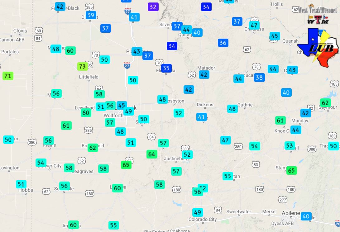
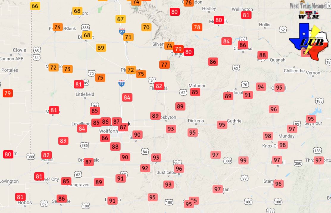
| Peak wind gusts measured by the Texas Tech West Texas Mesonet (WTM) on 10 October 2021. The peak sustained wind speeds from the WTM can be VIEWED HERE. |
| |
|
Sunday afternoon (10 October) brought strong winds and blowing dust to much of the South Plains. Wind gusts as high as 55 to 65 mph were common across the western, central and southern South Plains during the mid-late afternoon hours. A peak wind gust of 73 mph was recorded by the West Texas Mesonet (WTM) site near Amherst, where a thunderstorm passing by to the north enhanced the wind.
|
| |
 |
| Water vapor loop from 3:41 pm to 8:01 pm on 10 October 2021. |
| |
|
A compact but potent mid-level cyclone was the primary impetus for the winds. The most intense winds occurred as the cyclone emerged from New Mexico and raced across the Panhandles through the afternoon and early evening hours. In advance of the system, a cold front moved in from north during morning, then stalled over the northern South Plains. South of the front, strong daytime heating and deep mixing tapped into the low-level jet associated with the passing system. Sustained winds of 30 to 40 mph were common, gusting above 50 mph at times. The winds were further enhanced along and immediately behind a Pacific cold front that raced from west-to-east across the Caprock through the mid-late afternoon. The peak wind gusts at most locations occurred immediately behind the Pacific front, when several sites recorded gusts in excess of 58 mph. Although the most intense gusts didn't last long, they did loft copious amounts of dust, dropping the visibility as low as a mile for several minutes at the Lubbock Airport between 4:30 and 5 pm.
|
| |
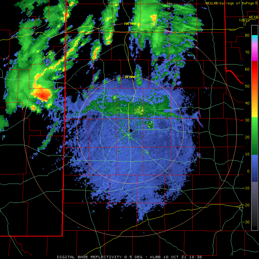 |
| Lubbock WSR-88D base reflectivity loop valid from 1:36 pm to 5:06 pm on 10 October 2021. |
| |
| North of the stationary front, and closer to where the center of the mid-upper level system emerged, scattered showers and isolated storms developed during the afternoon. The showers brought light to moderate rain for many spots across the southern Texas Panhandle. One more intense storm did provide brief heavy rain as it moved by just north of Muleshoe. This storm also enhanced the wind around the Amherst area, where the gust of 73 mph occurred. |
| |
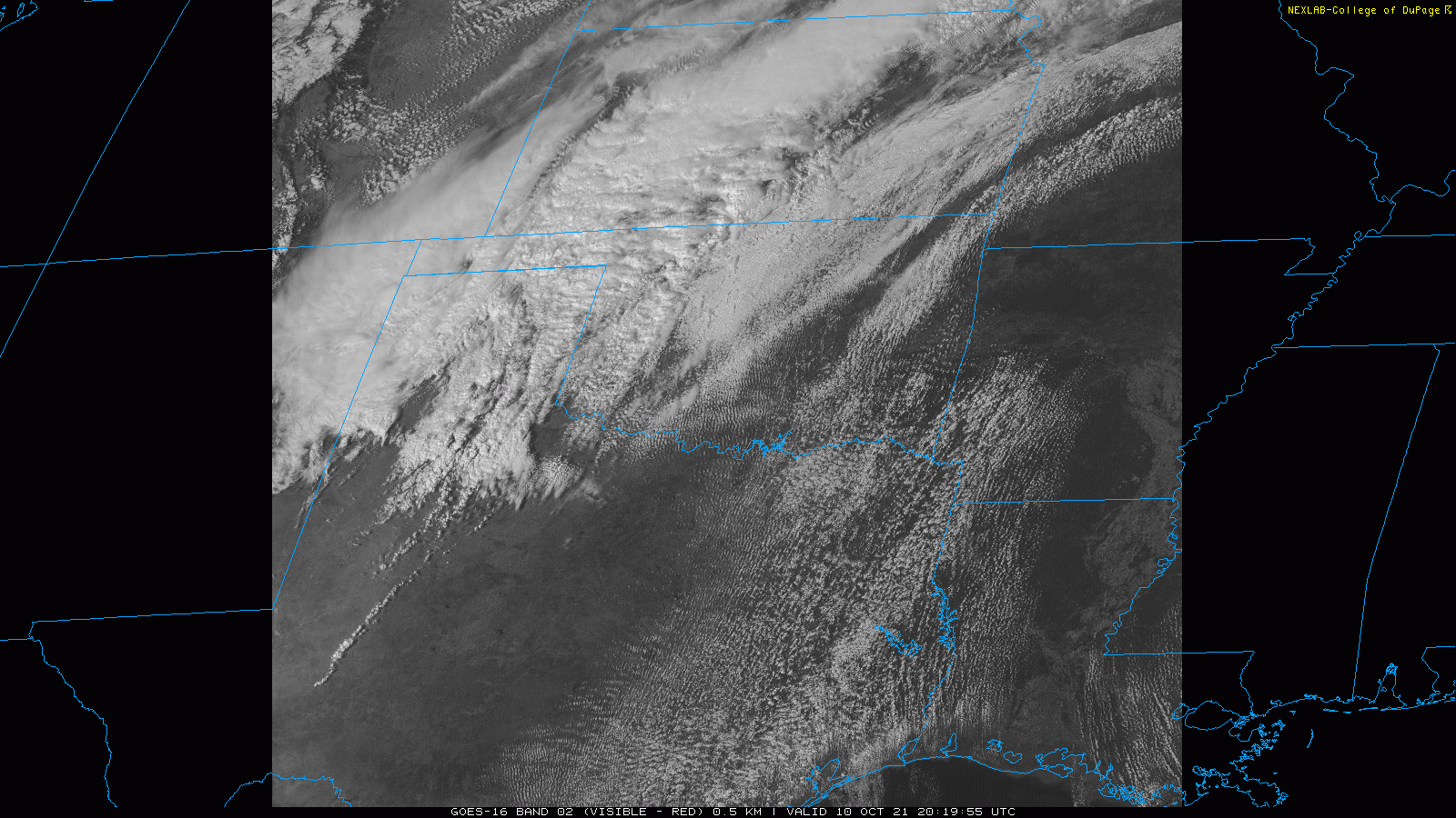 |
| Visible satellite loop from 3:19 pm to 5:11 pm on 10 October 2021. |
| |
| The above satellite animation shows the evolution of the dynamic storm system during the late afternoon hours. Blowing dust is clearly visible moving across the central and southern South Plains, especially along and immediately behind the advancing Pacific cold front. |
| |
 |
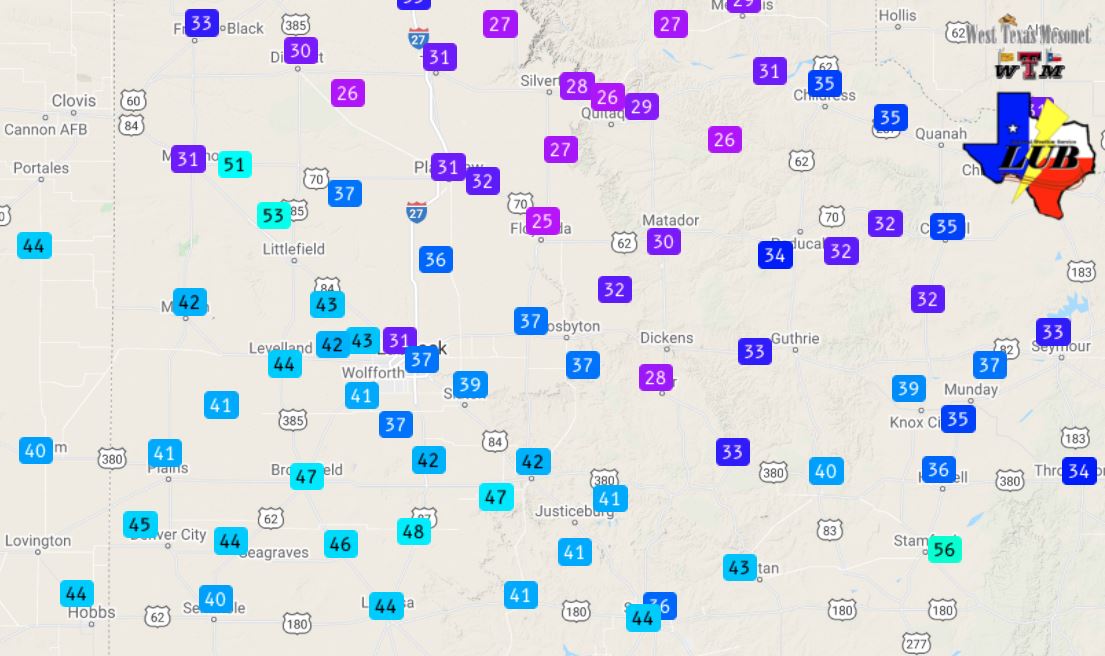
| High temperatures record by the West Texas Mesonet on 10 October 2021. |
| |
|
The powerful system and cold fronts also resulted in an impressive temperature gradient across the region. Highs on Sunday only reached the 60s for portions of the southwest Texas Panhandle, while they peaked near 100 degrees in the southern Rolling Plains. At one point in the late afternoon a 49 degree temperature difference existed between Friona and Aspermont.
|
| |
|
|
| Regional radar animation valid from 7:48 pm to 8:08 pm on Sunday (10 October 2021). |
| |
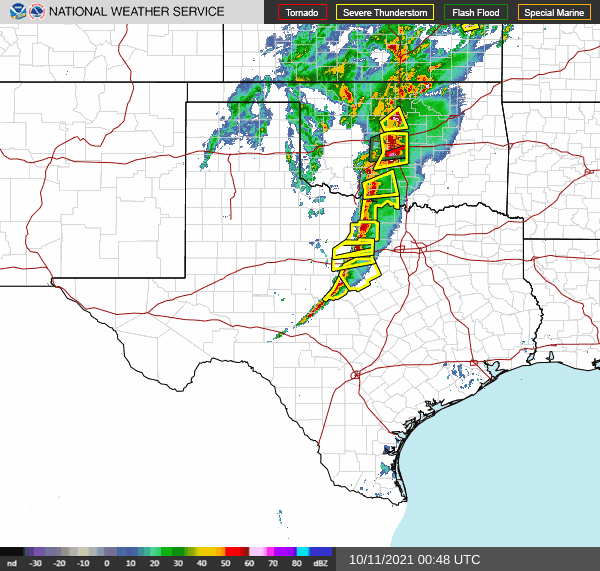
| When the Pacific front and storm system reached the better moisture and instability, thunderstorms erupted over Oklahoma and North Texas. Numerous reports of severe weather, including large hail, damaging winds and tornadoes, were received as this activity moved across Oklahoma and North Texas through the evening and late-night hours. |
| |
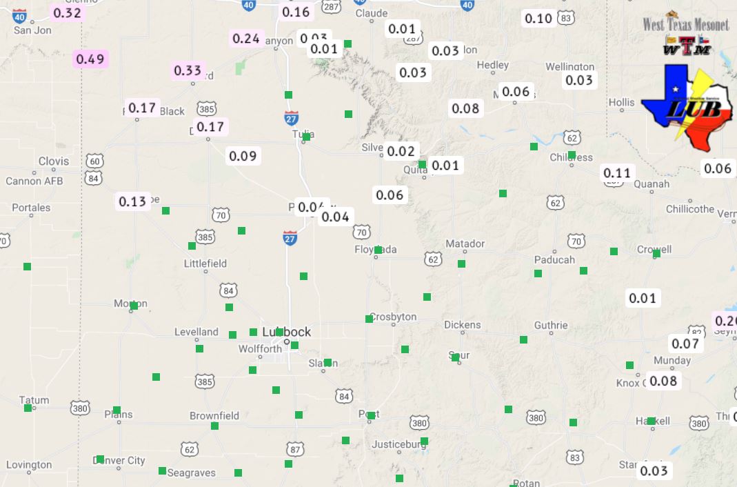 |
| 24-hour rain totals ending at 8:15 pm on Sunday evening (10 October). The data are courtesy of the West Texas Mesonet. |
| |
| Closer to home, rain totals were on the light side, mostly ranging from a few hundredths to a couple tenths of an inch across the southern Texas Panhandle. Locally heavier amounts, in excess of a half inch, likely fell north of Muleshoe with the one more intense storm that moved through. Further south, where the strongest winds and blowing dust occurred, no rain fell. |
| |
|
The preliminary storm reports collected on this windy day can be found below.
|