Late June severe t-storms and heavy rain 25-29 June 2021
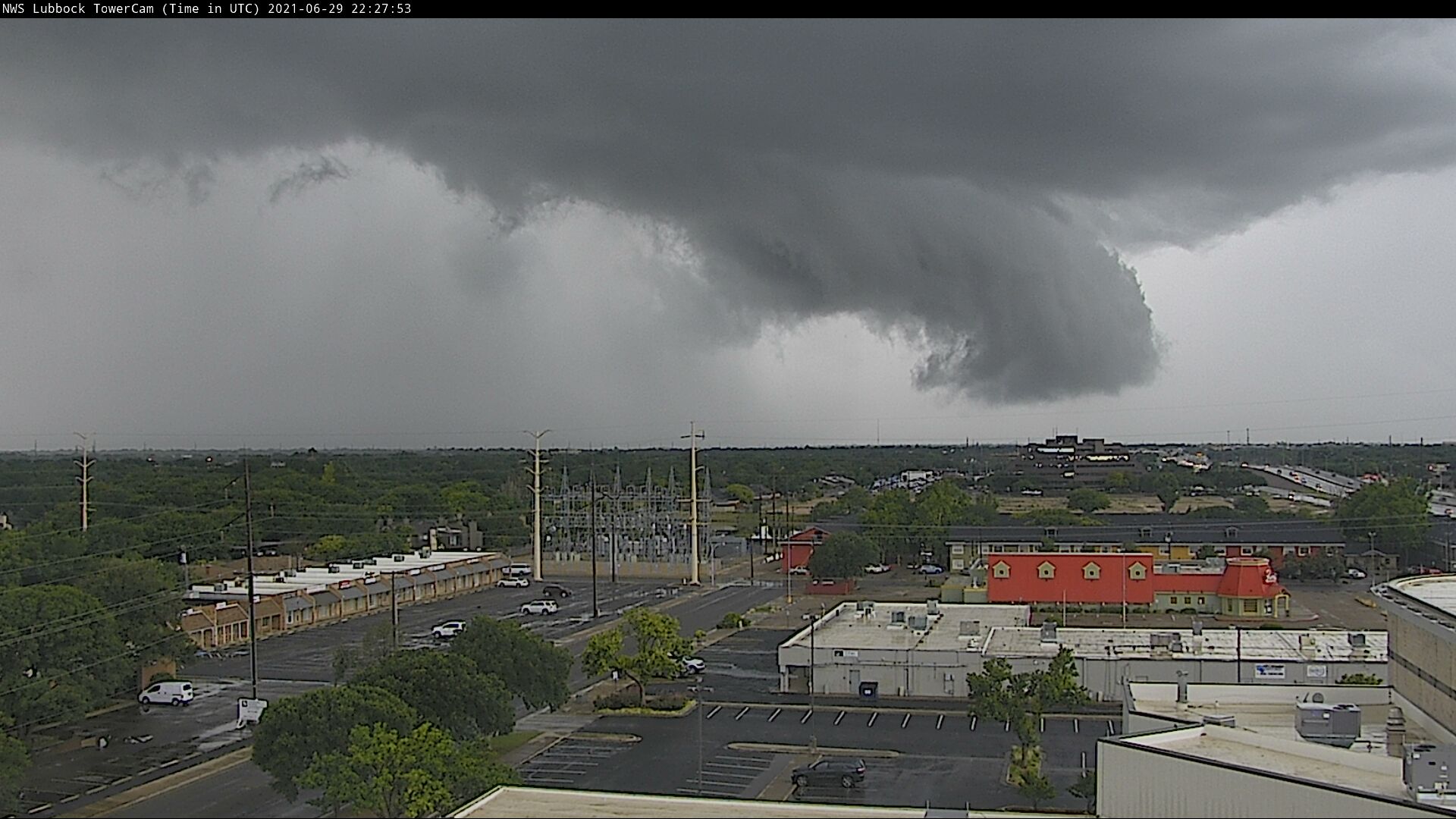
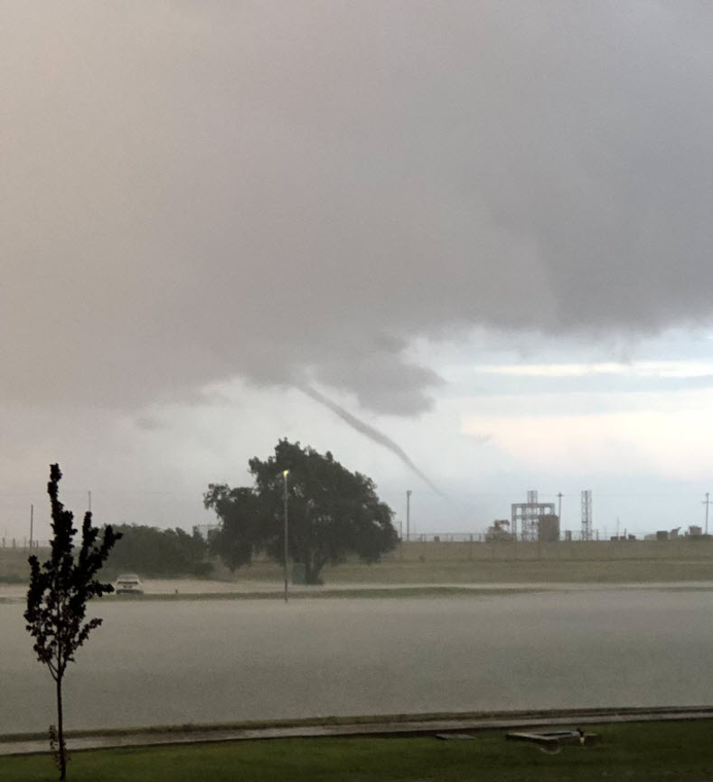
Ominous clouds and torrential rain moving across southwest Lubbock late Tuesday afternoon (29 June 2021).
After a couple of hot and dry weeks through the middle of June, the weather took a sharp turn back toward the cooler and wetter side. The shift back to the late May and early June-like weather was inspired by the approach and passage of a cold front and slow-moving upper level trough.
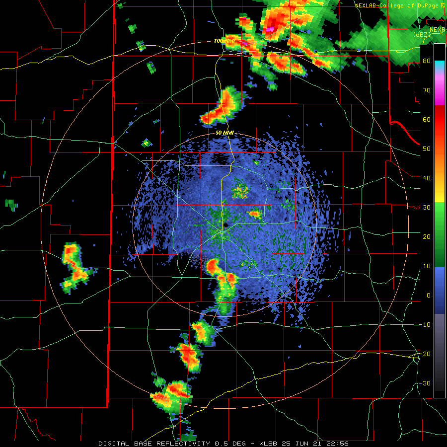
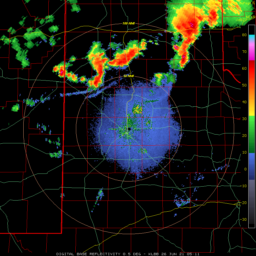
Lubbock WSR-88D base reflectivity loop valid from 5:56 pm to 9:47 pm 25 June 2021. An additional radar animation the following morning, valid from 12:11 am to 5:51 am on the 26th, can be VIEWED HERE.
The active stretch kicked off in earnest with a bout of widely scattered thunderstorms Friday evening (25 June). The initial storms developed along and ahead of a dryline, then raced east and northeastward across the South Plains region. Relatively hot and dry conditions in place kept rainfall spotty, but did support strong downdrafts that produced severe gusts.
Peak wind gusts measured by the West Texas Mesonet on Friday, 25 June 2021.
A peak wind gust of 75 mph was measured by the West Texas Mesonet (WTM) site located 3 miles north-northwest of McAdoo Friday evening. In addition, the south-central Texas Panhandle recorded a couple of rounds of severe-caliber winds. The Vigo Park WTM had a peak gust of 59 mph as a storm moved through just before 7 pm, then another gust to 67 mph just after 1 am the next day, as another round of overnight storms tracked across the southern Texas Panhandle. The late-night activity tracked repeatedly across the southern Panhandle and produced heavy rainfall, in excess of 3 inches at both Happy and Vigo Park.
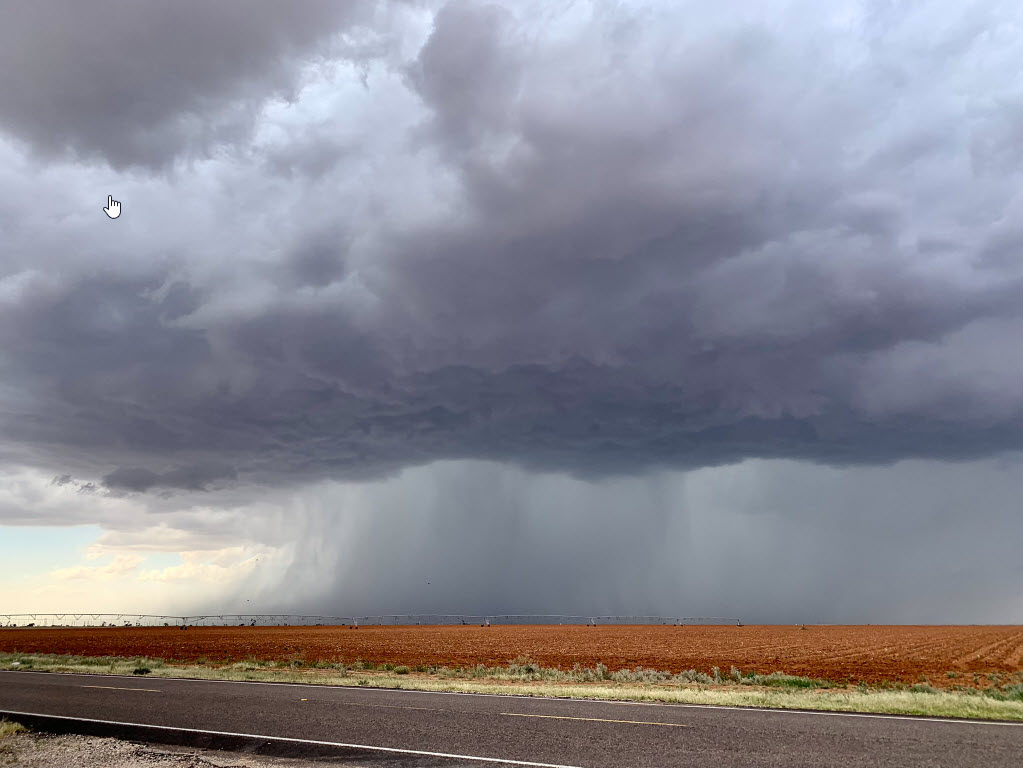
Base of an intense thunderstorm developing near Plains, TX, early Saturday evening (26 June 2021). The picture is courtesy of Adam Springer.
The following day, Saturday the 26th, brought the most widespread and impactful weather to the region. The robust storms were fueled by abundant moisture and instability, a stationary frontal boundary, increased winds aloft associated with an approaching disturbance, and the dryline. The magnitude of the instability and wind shear were sufficient to cause many of the initial storms that developed to rotate, becoming supercells. These left and right-moving storms generated large hail, damaging winds and torrential rainfall. Hail as large as 2 inches in diameter was observed at the Muleshoe Wildlife Refuge.
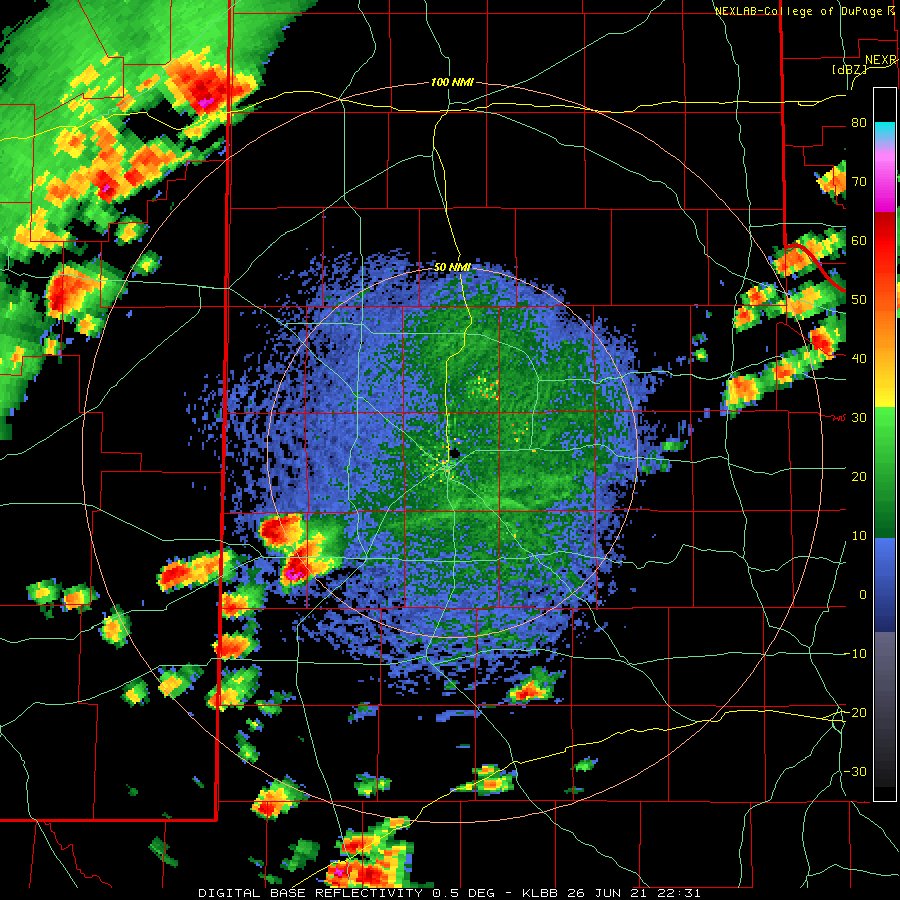
Lubbock WSR-88D base reflectivity loop valid from 5:31 pm to 9:23 pm 26 June 2021. A regional radar animation, valid from 9:14 pm to 9:32 pm, can be VIEWED HERE.
The thunderstorms quickly grew upscale into a line of storms that swept across the Caprock and into the Rolling Plains late Saturday evening/night. Damaging wind gusts of 55 to 75 mph were common with the line of storms as it moved through. Peak wind gusts of 76 mph were measured at the Morton, Amherst and Slaton WTM sites, while the Lubbock Airport officially measured a peak gust of 68 mph.
Peak wind gusts measured by the West Texas Mesonet through 915 pm on Saturday (26 June 2021).
The severe winds downed power poles near Pep and snapped tree limbs in Lubbock. Intense rain rates also lead to areas of flooding and flash flooding, including near Whitharral where portions of Highway 385 flooded.
Landspout tornado observed near Levelland just before 9 pm on Sunday evening (27 June 2021). A Lubbock radar animation, valid from 7:32 pm to 9:30 pm on the 27th, can be VIEWED HERE.
Instability and wind shear waned in the following days, but abundant moisture lingered. The near-record level moisture fueled several rounds of tropical showers and the occasional embedded thunderstorm. The main impact from these showers were periods of torrential rainfall, though they did also support several tropical-type funnels, and even a brief landspout or two.
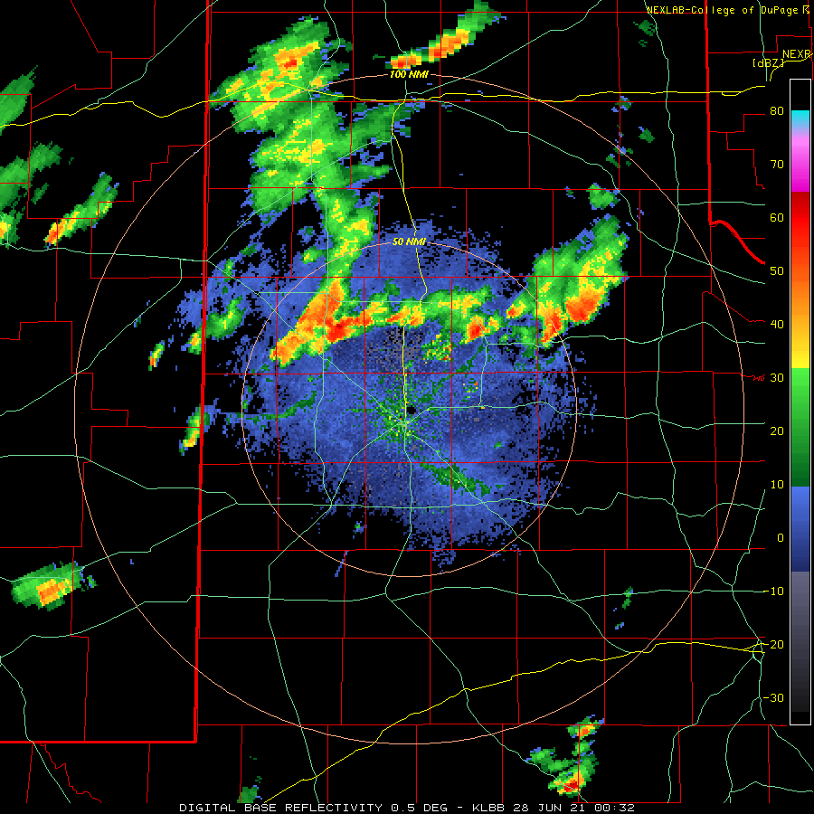
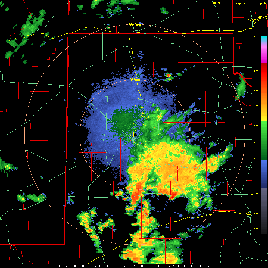
Lubbock WSR-88D base reflectivity loop valid from 4:15 am to 6:04 am on Monday (28 June 2021).
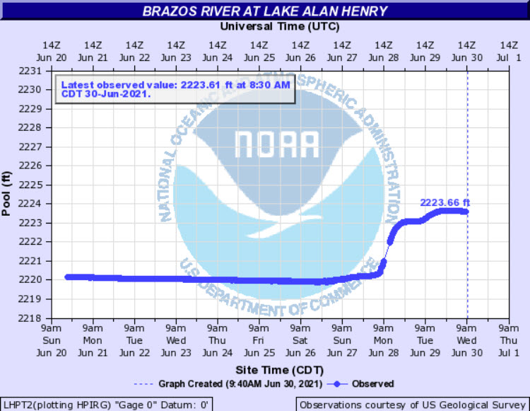
The landspout-type tornadoes did no known damage, as is generally expected since they often do not persist long or contain very strong winds. However, where the tropical showers trained they unloaded excessive amounts of water that led to flooding. On Monday morning, June 28th, the Lake Alan Henry area experience a prolonged period of moderate to heavy rain. The Lake Alan Henry WTM recorded 5.18 inches on the 28th, much of which fell in a 3-hour period centered around 9 am. The excessive rain flooded portions of Highway 84 between Post and Justiceburg and inundated structures near Lake Alan Henry.
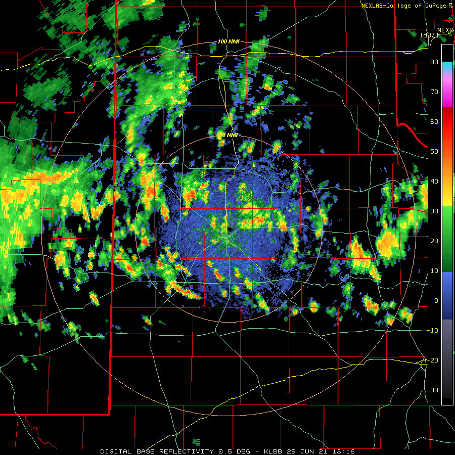
Tropical funnel cloud captured east of Slaton around 11:30 am Tuesday (29 June 2021). The image is courtesy of Corey Elliott. The Lubbock WSR-88D base reflectivity loop valid from 1:16 pm to 8:49 pm on the 29th can be VIEWED HERE.
Scattered tropical showers generated additional funnel clouds and localized flooding on Tuesday, June 29th. One small but intense downpour took aim on the southwestern portion of Lubbock County, where a quick 1 to 2 inches fell, causing street flooding during rush hour. The coverage and intensity of the showers waned Tuesday night, but another round of showers did affect the southern Texas Panhandle and western South Plains on Wednesday (30 June 2021).
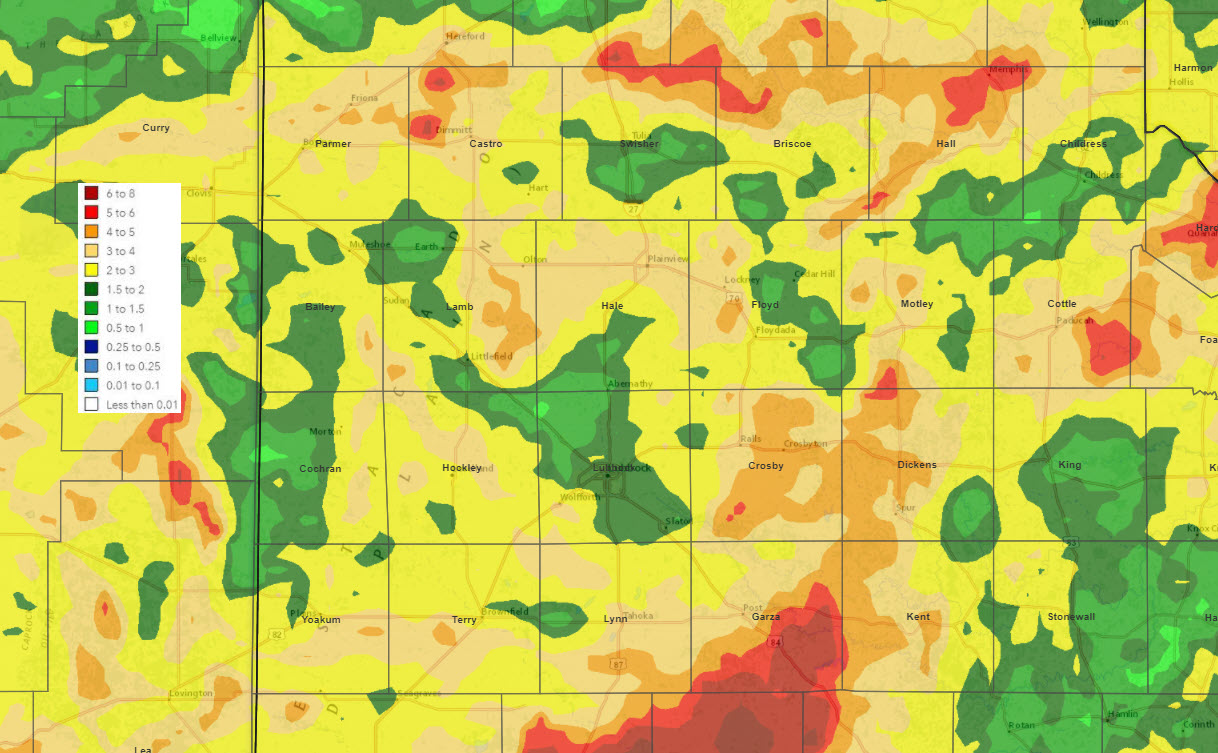
7-day radar-estimated and bias-corrected rainfall ending at 7 am on Wednesday (30 June 2021). The 5-day rain totals ending at 9:30 am on the 30th, measured by the West Texas Mesonet, can be FOUND HERE. A close up of the 5-day total, zoomed in to Lubbock, can be VIEWED HERE.
Over the course of the active late-June stretch, the entire region picked up significant rainfall. Many locations recorded 2 to 4+ inches, with pockets of 5 to 7+ inches. Officially, the Lubbock Airport measured 1.48 inches between June 25th and 29th, which was on the lower side, though still significant. This boosted the year-to-date (YTD) total to 12.09 inches, or 3.17 inches above average. Childress officially recorded 1.46 inches over this same stretch, raising their YTD total to 9.79 inches, or 2.69 inches below average.
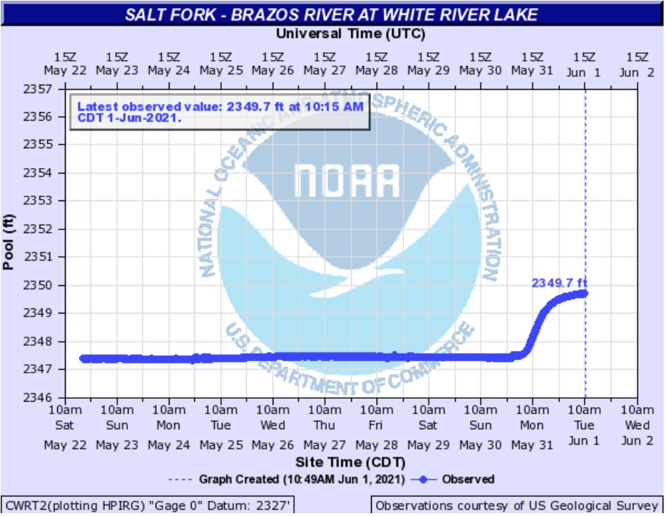
Water levels observed at Lake Alan Henry (left) and White River Lake (right) in late June 2021. The conservation level (lake deemed full) is 2,220 feet for Lake Alan Henry.
Runoff from the heavy rain did result in significant rises on Lake Alan Henry, lifting it nearly 4 feet, and pushing it back over the spillway (to 111% of capacity). White River Lake rose about 2 feet, causing it to rise from 19% to 25% of capacity.
The preliminary storm reports collected during the active late-June stretch can be found below.
Storm Reports from June 25th
PRELIMINARY LOCAL STORM REPORT...SUMMARY
NATIONAL WEATHER SERVICE LUBBOCK TX
524 AM CDT SAT JUN 26 2021

..TIME...   ...EVENT...      ...CITY LOCATION...     ...LAT.LON...
..DATE...   ....MAG....      ..COUNTY LOCATION..ST.. ...SOURCE....
            ..REMARKS..

0558 PM     TSTM WND GST     HAPPY                   34.74N 101.84W
06/25/2021  M58 MPH          SWISHER            TX   MESONET

0648 PM     TSTM WND GST     VIGO PARK               34.65N 101.50W
06/25/2021  M59 MPH          SWISHER            TX   MESONET

0740 PM     TSTM WND GST     3 NNW MCADOO            33.77N 101.03W
06/25/2021  M75 MPH          DICKENS            TX   MESONET

1247 AM     TSTM WND GST     VIGO PARK               34.65N 101.50W
06/26/2021  M58 MPH          SWISHER            TX   MESONET

            WEST TEXAS MESONET

0107 AM     TSTM WND GST     VIGO PARK               34.65N 101.50W
06/26/2021  M67 MPH          SWISHER            TX   MESONET

            WEST TEXAS MESONET

0135 AM     TSTM WND GST     CAPROCK CANYON SP       34.41N 101.06W
06/26/2021  M60 MPH          BRISCOE            TX   MESONET

            WEST TEXAS MESONET
Storm Reports on June 26th
PRELIMINARY LOCAL STORM REPORT...SUMMARY
NATIONAL WEATHER SERVICE LUBBOCK TX
658 AM CDT SUN JUN 27 2021

..TIME...   ...EVENT...      ...CITY LOCATION...     ...LAT.LON...
..DATE...   ....MAG....      ..COUNTY LOCATION..ST.. ...SOURCE....
            ..REMARKS..

0539 PM     HAIL             9 SW TOKIO              33.09N 102.68W
06/26/2021  E1.00 INCH       YOAKUM             TX   TRAINED SPOTTER

0705 PM     TSTM WND GST     1 ENE MORTON            33.73N 102.74W
06/26/2021  M72 MPH          COCHRAN            TX   MESONET

0706 PM     HAIL             1 E MORTON              33.72N 102.74W
06/26/2021  E0.88 INCH       COCHRAN            TX   TRAINED SPOTTER

0810 PM     TSTM WND GST     2 SSW MULESHOE          34.21N 102.74W
06/26/2021  M61 MPH          BAILEY             TX   MESONET

0810 PM     TSTM WND GST     1 ENE MORTON            33.73N 102.74W
06/26/2021  M76 MPH          COCHRAN            TX   MESONET

0818 PM     HAIL             MULESHOE WILDLIFE REFUG 33.95N 102.75W
06/26/2021  E2.00 INCH       BAILEY             TX   SOCIAL MEDIA

            VIDEO RECEIVED VIA TWITTER.

0841 PM     TSTM WND GST     1 NE AMHERST            34.02N 102.40W
06/26/2021  M76 MPH          LAMB               TX   MESONET

0901 PM     TSTM WND GST     4 S LEVELLAND           33.53N 102.36W
06/26/2021  M66 MPH          HOCKLEY            TX   MESONET

            WEST TEXAS MESONET

0910 PM     TSTM WND GST     6 SSW ANTON             33.73N 102.19W
06/26/2021  M64 MPH          HOCKLEY            TX   MESONET

            WEST TEXAS MESONET

0917 PM     HAIL             ABERNATHY               33.83N 101.84W
06/26/2021  E1.75 INCH       LUBBOCK            TX   PUBLIC

0924 PM     TSTM WND DMG     2 S PEP                 33.79N 102.56W
06/26/2021                   HOCKLEY            TX   TRAINED SPOTTER

            POWER POLES DOWN ALONG ROADWAY

0934 PM     FLASH FLOOD      3 SSW WHITHARRAL        33.70N 102.34W
06/26/2021                   HOCKLEY            TX   TRAINED SPOTTER

            LOW-LYING AREAS OF HWY 385 FLOODED BETWEEN 1294 RD AND
            SPAIN RD

0944 PM     TSTM WND DMG     LUBBOCK SOUTH PLAI      33.54N 101.92W
06/26/2021                   LUBBOCK            TX   TRAINED SPOTTER

            ONE FOOT DIAMETER TREE LIMB SNAPPED. TIME ESTIMATED
            FROM RADAR.

0945 PM     TSTM WND GST     3 WNW LUBBOCK           33.60N 101.90W
06/26/2021  M69 MPH          LUBBOCK            TX   MESONET

            WEST TEXAS MESONET

0945 PM     TSTM WND GST     REESE CENTER            33.61N 102.05W
06/26/2021  M57 MPH          LUBBOCK            TX   MESONET

            WEST TEXAS MESONET

0946 PM     TSTM WND GST     REESE CENTER            33.61N 102.05W
06/26/2021  M57 MPH          LUBBOCK            TX   MESONET

            WEST TEXAS MESONET

0946 PM     TSTM WND GST     6 NNE LUBBOCK           33.67N 101.82W
06/26/2021  M68 MPH          LUBBOCK            TX   ASOS

0951 PM     TSTM WND GST     2 WNW BURRIS            33.54N 101.81W
06/26/2021  M57 MPH          LUBBOCK            TX   MESONET

            WEST TEXAS MESONET

1002 PM     TSTM WND GST     1 S PLAINVIEW           34.18N 101.71W
06/26/2021  M64 MPH          HALE               TX   MESONET

            WEST TEXAS MESONET

1004 PM     TSTM WND GST     3 NNE TAHOKA            33.21N 101.78W
06/26/2021  M64 MPH          LYNN               TX   MESONET

            WEST TEXAS MESONET

1009 PM     TSTM WND GST     2 NE SLATON             33.46N 101.62W
06/26/2021  M72 MPH          LUBBOCK            TX   MESONET

            WEST TEXAS MESONET

1011 PM     TSTM WND GST     2 NE SLATON             33.46N 101.62W
06/26/2021  M76 MPH          LUBBOCK            TX   MESONET

            WEST TEXAS MESONET

1027 PM     TSTM WND GST     1 NE POST               33.20N 101.37W
06/26/2021  M63 MPH          GARZA              TX   MESONET

            WEST TEXAS MESONET

1045 PM     TSTM WND GST     6 NW WHITE RIVER LAKE   33.53N 101.17W
06/26/2021  M67 MPH          CROSBY             TX   MESONET

            WEST TEXAS MESONET

1047 PM     TSTM WND GST     6 NW WHITE RIVER LAKE   33.53N 101.17W
06/26/2021  M69 MPH          CROSBY             TX   MESONET

            WEST TEXAS MESONET

0556 AM     FLOOD            3 ESE DOWNTOWN LUBBOCK  33.57N 101.80W
06/27/2021                   LUBBOCK            TX   EMERGENCY MNGR

            18-24" OF WATER OVER ROAD AT SPILLWAY OF CANYON LAKE #6
Storm Reports on June 27th
PRELIMINARY LOCAL STORM REPORT
NATIONAL WEATHER SERVICE LUBBOCK TX
1118 AM CDT MON JUN 28 2021

..TIME...   ...EVENT...      ...CITY LOCATION...     ...LAT.LON...
..DATE...   ....MAG....      ..COUNTY LOCATION..ST.. ...SOURCE....
            ..REMARKS..

0415 PM     FUNNEL CLOUD     RALLS                   33.68N 101.38W
06/27/2021                   CROSBY             TX   PUBLIC

            A LANDSPOUT FUNNEL WAS PHOTOGRAPHED AND REPORTED.

0854 PM     TORNADO          1 S OPDYKE WEST         33.57N 102.30W
06/27/2021                   HOCKLEY            TX   SOCIAL MEDIA

            BRIEF ROPE - NO DAMAGE REPORTED

1120 PM     DOWNBURST        1 NNW OPDYKE            33.61N 102.28W
06/27/2021  E70 MPH          HOCKLEY            TX   EMERGENCY MNGR

            TWO 12 KVA POLES SNAPPED

1120 PM     DOWNBURST        2 N OPDYKE WEST         33.62N 102.30W
06/27/2021  U0 MPH           HOCKLEY            TX   FIRE DEPT/RESCUE

            REPORTS OF POWER FLASHES
Storm Reports on June 28th
PRELIMINARY LOCAL STORM REPORT
NATIONAL WEATHER SERVICE LUBBOCK TX
1109 AM CDT MON JUN 28 2021

..TIME...   ...EVENT...      ...CITY LOCATION...     ...LAT.LON...
..DATE...   ....MAG....      ..COUNTY LOCATION..ST.. ...SOURCE....
            ..REMARKS..

0855 AM     FLOOD            3 NW JUSTICEBURG        33.08N 101.24W
06/28/2021                   GARZA              TX   LAW ENFORCEMENT

            GARZA COUNTY SHERIFF REPORTS MULTIPLE AREAS OF WATER
            RUNNING OVER THE ROADWAY ON US-84 BETWEEN POST AND
            JUSTICEBURG.

1100 AM     FLOOD            4 WSW LAKE ALAN HENRY   33.05N 101.11W
06/28/2021                   GARZA              TX   SOCIAL MEDIA

            WATER ENCROACHING INTO STRUCTURES


