Scattered thunderstorms produce large hail and a tornado 23 April 2021
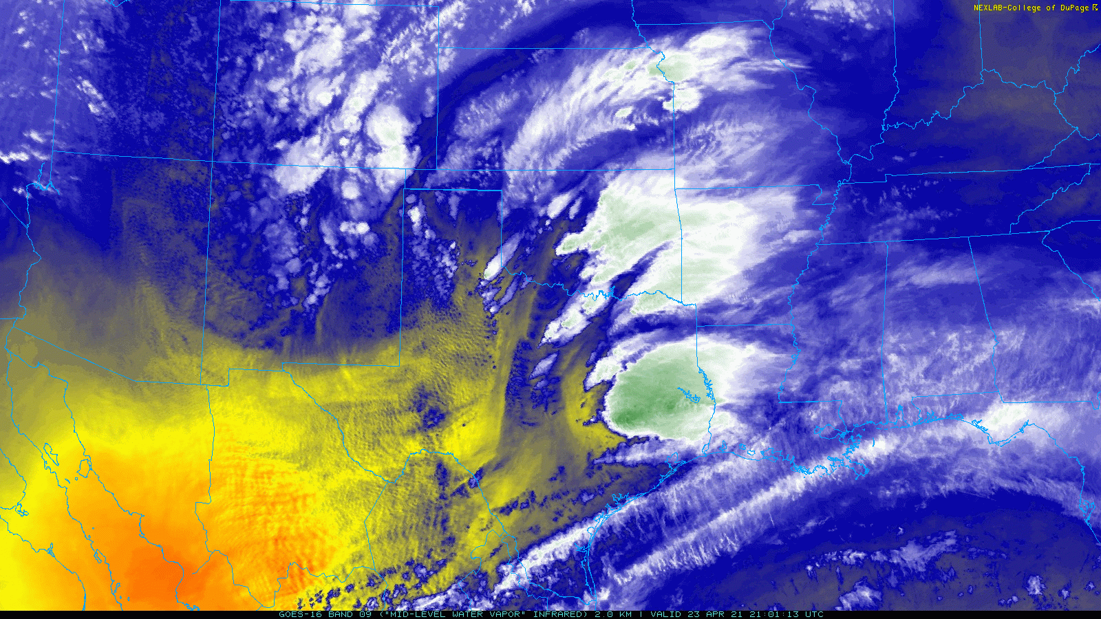
Mid-level water vapor loop captured by GOES-16 from 4:01 pm to 4:36 pm on 23 April 2021.
An approaching upper level storm system, in combination with a sharpening dryline, generated a round of scattered thunderstorms across the southeastern Texas Panhandle and Rolling Plains Friday afternoon and evening (23 April).
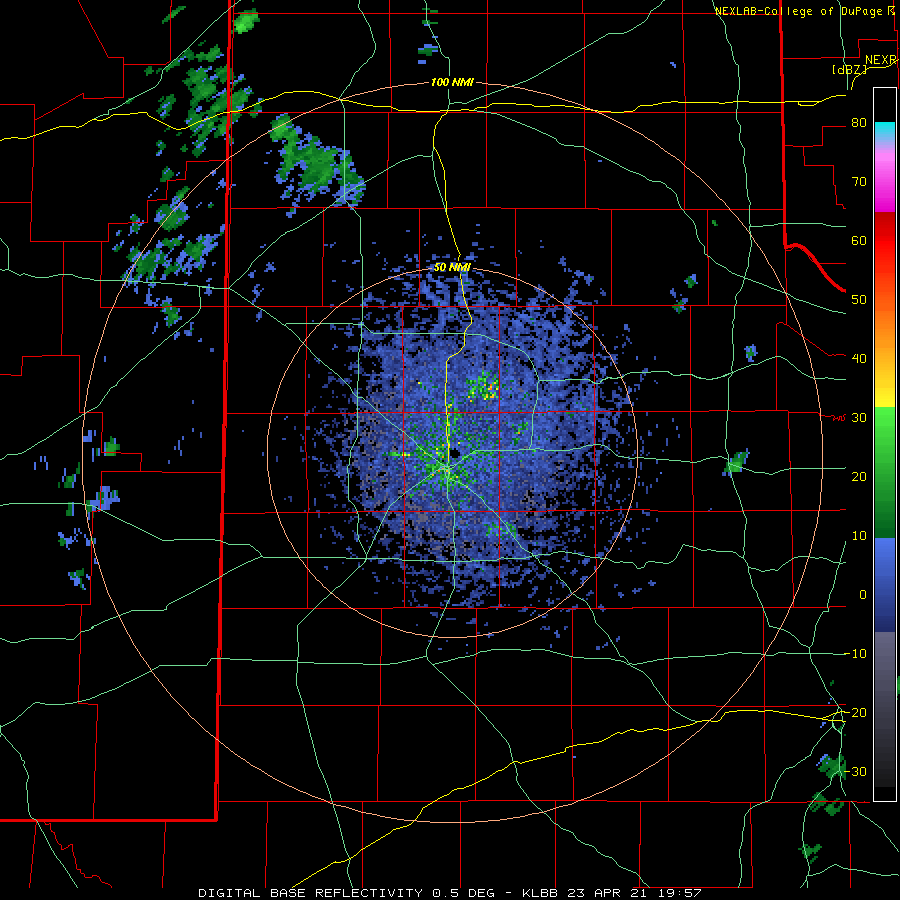
Lubbock WSR-88D loop valid from 2:57 pm to 4:49 pm on 23 April 2021.
The first storms formed along the dryline during the mid-afternoon over the Rolling Plains as temperatures warmed into the 70s and 80s. Relatively rich moisture and strong instability east of the dryline fed the thunderstorms, while strong vertical wind shear caused the storms to organize and rotate. One thunderstorm quickly intensified as it tracked eastward across northern Cottle County, dropping hail estimated as large as golf balls as it moved near Cee Vee and Swearingen.
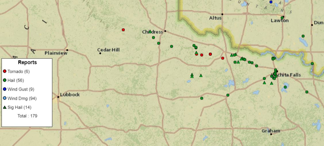
Preliminary storm reports received for 23 April 2021.
Additional showers and thunderstorms followed the initial round. This activity produced strong wind gusts as it emerged across the western and central Texas Panhandle, but quickly intensified as it encountered the better moisture and instability residing off the Caprock. One particularly intense storm produced a tornado as it passed northeast of Turkey. This storm went on to produce 2" diameter hail south of Estelline and quarter size hail near Tell as it propagated east-southeastward.
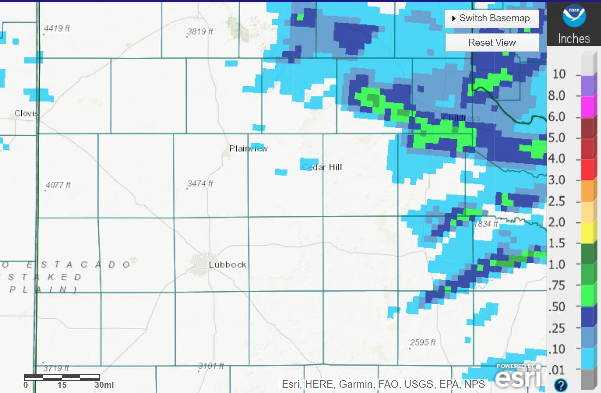
Radar-estimated and bias-corrected rainfall for 23 April 2021.
Welcome rain accompanied the thunderstorms, though only a few narrow swaths of appreciable rainfall occurred. The heaviest rainfall, estimated between a half inch and inch, stretched from central Hall County into southern Childress and northern Cottle Counties. The Childress Airport officially recorded 0.17 inches of rain on the 23rd.
The preliminary wind reports collected during this event can be found below.
Preliminary Storm Reports from April 23rd
PRELIMINARY LOCAL STORM REPORT...SUMMARY
NATIONAL WEATHER SERVICE LUBBOCK TX
922 PM CDT FRI APR 23 2021

..TIME...   ...EVENT...      ...CITY LOCATION...     ...LAT.LON...
..DATE...   ....MAG....      ..COUNTY LOCATION..ST.. ...SOURCE....
            ..REMARKS..

0427 PM     HAIL             8 ENE CEE VEE           34.27N 100.31W
04/23/2021  E1.75 INCH       COTTLE             TX   STORM CHASER

0453 PM     HAIL             6 NNE SWEARINGEN        34.23N 100.11W
04/23/2021  E1.50 INCH       COTTLE             TX   STORM CHASER

0525 PM     NON-TSTM WND GST TULIA                   34.54N 101.77W
04/23/2021  M58 MPH          SWISHER            TX   MESONET

            VIRGA INDUCED DOWNBURST

0531 PM     TORNADO          4 NE TURKEY             34.44N 100.85W
04/23/2021                   HALL               TX   FIRE DEPT/RESCUE

0613 PM     HAIL             9 S ESTELLINE           34.42N 100.44W
04/23/2021  E2.00 INCH       HALL               TX   EMERGENCY MNGR

0643 PM     HAIL             3 S TELL                34.34N 100.39W
04/23/2021  E1.00 INCH       CHILDRESS          TX   CO-OP OBSERVER
Damage Survey from WFO Norman for the 23rd
Public Information Statement
National Weather Service Norman OK
1124 AM CDT Sun Apr 25 2021

...Public Information Statement...

...NWS Damage Survey For 4/23/2021 Tornado Event

.Overview...At least five tornadoes were observed across
southeastern Hardeman County into western Wilbarger County on
Friday afternoon and evening. The only damage in Hardeman County
reported to the NWS or local emergency management was some damage
to crops and a cattle feeder in southeastern Hardeman County,
otherwise the first three tornadoes occurred in inaccessible areas
near and north of the Pease River. At one point, two tornadoes
were occurring simultaneously in southeast Hardeman County. The
tornadic storm moved across the Pease River and into Wilbarger
County where a damage survey was conducted on Saturday.
Investigation continues on whether one of the two simultaneous
tornadoes in Hardeman County continued east-southeast and
produced the EF2 damage listed below west of Lockett, or if the
initial tornadoes dissipated before the EF2 listed below
developed.

.West of Lockett...

Rating:                 EF2
Estimated Peak Wind:    115 to 120 mph
Path Length /statute/:  At least 4 miles
Path Width /maximum/:   300 yards
Fatalities:             0
Injuries:               0

Start Date:             04/23/2021
Start Time:             06:15 PM CDT
Start Location:         2 NNE Rayland / Wilbarger County / TX
Start Lat/Lon:          34.10 / -99.46

End Date:               04/23/2021
End Time:               06:22 PM CDT
End Location:           1 W Lockett / Wilbarger County / TX
End Lat/Lon:            34.09 / -99.39

Summary: This tornado developed near the Pease River and
initially moved southeast. Heavy damage occurred on a farmstead 3
miles west of Lockett where a home suffered significant damage,
outbuildings were destroyed or heavily damaged, and vehicles and
farm implements were displaced, including a pick-up truck tossed
100 yards to the south-southwest. The tornado then turned eastward
and was observed to dissipate just west of the town of Lockett.
The tornado may have initially developed north of the Pease River
in Hardeman County and analysis of this tornado continues.

.East of Lockett...

Rating:                 EF1
Estimated Peak Wind:    100 to 105 mph
Path Length /statute/:  3 miles
Path Width /maximum/:   300 yards
Fatalities:             0
Injuries:               0

Start Date:             04/23/2021
Start Time:             06:34 PM CDT
Start Location:         2 ESE Lockett / Wilbarger County / TX
Start Lat/Lon:          34.08 / -99.33

End Date:               04/23/2021
End Time:               06:42 PM CDT
End Location:           5 ESE Lockett / Wilbarger County / TX
End Lat/Lon:            34.06 / -99.28

Summary: This tornado was observed developing about 2 miles east-
southeast of Lockett. The first significant damage was roof
damage to a home 2.5 miles east-southeast of Lockett and
outbuildings were destroyed. Tree, power pole, fence and
outbuilding damage continued as the tornado moved southeast.
The ending location was estimated based on spotter reports.

EF Scale: The Enhanced Fujita Scale classifies tornadoes into
the following categories.

EF0...Weak......65 TO 85 mph
EF1...Weak......86 TO 110 mph
EF2...Strong....111 TO 135 mph
EF3...Strong....136 TO 165 mph
EF4...Violent...166 TO 200 mph
EF5...Violent...>200 mph

NOTE:
The information in this statement is preliminary and subject to
change pending final review of the events and publication in
NWS Storm Data.